|
|
|||


|
|
|
||||||||||||||||||||||
|
|
|||||||||||||||||||||
|
|
|||||||||||||||||||||
|
||||||||||||||||||||||
 |
CALHOUN'S FIRST PRIMITIVE ROAD BUILT IN 1820 - Dug, Dredged, And Carved By Hard Labor |
| (04/16/2026) |
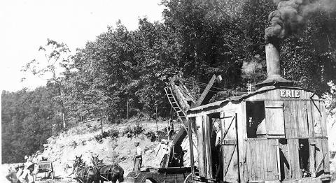
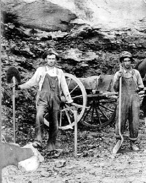
Mechanized equipment first came to the county shortly after the turn Introduction: Historian Bob Bonar has long been fascinated with early road building in Calhoun County, often commenting how the labor intensive roads were built without mechanized equipment. Bonar has an eye for earthworks, quarries, road fills and drainage. Many of the early roads actually were in creek beds, even into the late 20th century. Bonar's research on early Calhoun Roads will be transferred to a map. By Robert Bonar 2006 President of Calhoun Historical Society The first road through what is now Calhoun County was constructed in the 1820's when the area was a portion of western Lewis County. A "state road" connecting the West Fork River valley with Charleston followed the general route of present-day Routes 33/119 until it reached the forks of Steer Creek [Stumptown]. According to Col. D.S. Deweese, the road did not go up Bear Fork like it does today but went "over the mountain" to the upper West Fork of the Little Kanawha River. It turned up White Oak, across to the head of Beech, across the ridge to the headwaters of Big Sandy Creek, then down Big Sandy to the Elk River. Apparently, this is the Charleston Road mentioned in early records. There is a survey for the Charleston-Weston Turnpike dated 1835, which details a similar route except it left the forks of Steer Creek and went up Straight Fork [Bear Fork], over Sandy [Sand] Ridge, and crossed the West Fork near Benjamin Arnold's. Then the route went up Anthony Run, crossed Beech Fork, the old Lewis-Kanawha County line and Henry's Fork to Canoe Run. At the head of Canoe it went through a low gap to the headwaters of Big Sandy Creek. However, there is no certainty that this road was ever completed as surveyed. In the 1850's the Gilmer-Ripley Turnpike was constructed from Stumptown through Arnoldsburg, where it intersected with the main West Fork road, and on to California [Spencer] and Ripley following much of today's Route 33. Early records also mention the Pocatalico Road which apparently went up Sams Run from Beech, over the dividing ridge to Linden and Looneyville, and down the Pocatalico River. As the Little Kanawha watershed attracted more settlers, additional roads were built by Lewis, and later, the new Gilmer County. After Calhoun County was created, some of the first actions of the county court in 1856 were to improve and extend existing roads and create new ones. During the Civil War, county government came to a standstill and no records exist. The first post-War mention of road orders in county court minutes was in September, 1865.
An early 20th Century road crew on Steer Creek, 1916, Although there were surely others, roads that existed before Calhoun became a county that can be located with some certainty: - The main West Fork road. - The Little Kanawha River road [listed as the Ritchie-Gilmer Turnpike in 1855]. - The Gilmer-Ripley Turnpike. - The Charleston Road. - The Pocatalico Road. Here is a list of roads authorized in the early records of the Calhoun County Court. They are listed generally from north to south. [??=exact location uncertain]: - Up Five Mile Run from its mouth to the Wirt County line. - From the road near Frank Trippett's up Big Run to Uriah Ferrell's?? - ?? from Richards Mill up Yellow Creek to the head of Trace Fork. - From the forks of Big Root to ??Felix Collins. - From the school at the head of Leafbank and Phillip Norman's?? to the foot of the hill on Yellow Creek near Seth Rogers?? - Up Sugarcamp to Leading Creek and down Leading Creek to River Road from the forks of Annamoriah Creek by way of Lemuels Run to intersect River Road at Henderson Beall's ?? - From the neck of the Big Bend down the Little Kanawha to the Wirt County line. - From the neck of the Big Bend to Yellow Creek Bridge to Big Root Riffle. - From the top of Nighcut to Big Root Riffle up the River to Robinson Run. - From the mouth of Nighcut Run down the river by George Hardman's to Robinson Run. - Down the river from the mouth of Leafbank to Nighcut run and up the run to the top of the hill. - From the turnpike at the Burrows Farm [now Grantsville] by way of the mouth of Phillips Run to the mouth of Sinking Springs. - From the mouth of Flunk Riffle Run to Bethlehem Meeting House. - From the ford of Steer Creek to the mouth of Flunk Riffle Run from Muscle Shoals to Wolf Pen of Steer Creek. - From Laurel Shoals to Jane Rice's at the head of Wolf Pen Run. - From the ford on the Left Fork of Sycamore near Job Robinson's down the creek to the River Road near the old school house on the hill. - Mouth of Left Hand Fork of Millstone to the ford of Sycamore at Job Robinson's. - From the mouth of Daniels Run to the low gap one mile beyond William J. Proudfoot's. - From the mouth of Sinking Springs on the West Fork to Big Root Shoals on the Little Kanawha [later changed to Bell's Run with a grade not to exceed 5%]. - From the turnpike below Peregrine Hays [Arnoldsburg] down the West Fork to Lynch's Mill?? and on to Jacob Starcher's ?? - ?? from Given's Mill on the West Fork to intersect the road at the top of the hill between Rowells Run and the West Fork. - From the top of the hill above the mouth of Rowells Run down the West Fork to the Wirt County Line. - ?? from the Roane County line at Hiram Chapman's across the ridge to Rowells Run, up Rowells Run, and down Bee Creek to intersect the road near G. W. Hardman's. - From the Gilmer, Ripley, Ohio Turnpike at the head of Mushroom Run to the mouth of Beech. - From the mouth of Beech, up Beech to the Pocatalico Road. - From the mouth of Fink Run on the William May farm up Beech to William Cottrill farm at the Charleston Road. - Up the West Fork from the mouth of Millstone to opposite Mary Laughlin's ?? - From the head of Standing Stone [a tributary of Bear Fork] in Gilmer County to the mouth of Crooked Run. - Up Hardway Run from its mouth across Beech to the top of the Ridge dividing Beech and Henry's Fork. - From the top of the hill at the head of White Oak to the county line at the head of Beech. - Up Walker from its mouth to the Braxton [now Clay] County line. Here is a list of the roads authorized in the records of the Calhoun County Court in the three years after the Civil War. They are listed generally from north to south. [??=exact location uncertain]: - From the mouth of Yellow Creek to Rogers Mills?? on said creek. - ?? from Frank Ferrell's on Big Root to intersect the Yellow Creek Road at the widow Richards?? - From the mouth of Spring Fork of Yellow Creek up said Spring Fork to James W. Johnson's house on the hill. - From Simon P. Stump's farm on the Little Kanawha [Grantsville] and running with the dividing ridge between Bennetts Mill Run and Leafbank to James W. Johnson's house connecting with the Yellow Creek road—then the road from mouth of Bennetts Mill Run to the top of the Ridge will be vacated. - ??Pine Creek Road from Solomon Wilson's to the top of the ridge to intersect the Phillips Run road. - From the mouth of Road Fork of Sycamore Fork of Steer Creek so as to intersect the Phillips Run road at the low gap beyond William Barr's. - ?? from the top of the dividing ridge between Steer Creek and the Little Kanawha River so as to intersect the main Steer Creek road at John Stump's blacksmith shop?? - From the mouth of Barnes Run and running up said run to intersect the road running from the Little Kanawha to the West Fork at the head of said run at a deep gap [opposite the head of Mudlick]. - From the forks of Daniels Run above Jacob Starcher's up by way of Peter M. Booher's [the left fork] to intersect the West Fork and Little Kanawha River Road at the head of said run. - ?? from William Jarvis's and running up the Left Hand Fork of White Oak Fork of the West Fork by way of W. H. Jarvis and others to the Beech Fork at the Norman Farm?? - A. Knotts is to grade the road from Arnoldsburg up the West Fork to the County line and also on Buck Fork?? of the West Fork. Other roads referred to in County Court records: - September 11, 1865 main Pine Creek Road - November 10, 1865 main Steer Creek Road - March 15, 1867 ferry at the mouth of Annamoriah Creek where the turnpike crosses the river [Little Kanawha River]. - April 6, 1867 ferry at Grantsville opposite Simon P. Stump's house. - May 6, 1867 (a) constable is to notify Issac B. Cox to open the road from the pike near the widow Knight's house to the old road above Samuel W. Jeffries (b) C. H. and G. L. Richardson are permitted to place a gate opposite the mouth of Tripletts Run near the Richardson residence across a road leading to A. Springston's, and that he be permitted to erect a gate near the schoolhouse on the main West Fork Road. (c) Parkersburg Weston Turnpike |
|
|